Monday, April 7, 2014

Black & white aerial photo

http://online.redwoods.edu/instruct/colloquium/0607/

Black and White aerial photos are a type of remotely-sensed map typically taken by either satellite or airplane. Aerial photos taken in black and white are sensitive to the visible spectrum, much like the human eye. Presented above is a black and white aerial photo taken in 1952 of the Balloon Track Site which at the time was an operating rail yard. The contrasting shades of grey help to emphasize the muck and gravel mess created by rail yard industry in the center of the photograph.


Isobar

http://www.stuff.co.nz/the-press/news/your-weather/4139100/Rug-up-as-storm-approaches

Isobar maps use isobar contour lines in order to show air pressure in a geographic location at that given time.  The isobar line connects equal points of air pressure on the map. The isobar map above was released on September 17, 2010 in New Zealand to warn its inhabitants of the approaching severe weather. Winds during this westerly flowing storm were expected to reach between 120-130 kmh and had the potential to lift roofs off of houses! Isobaric maps like the one above a very important when it comes to explaining our weather and helping prepare for severe weather. 

Isopach

http://pubs.usgs.gov/fs/fs115-99/fs115-99.html

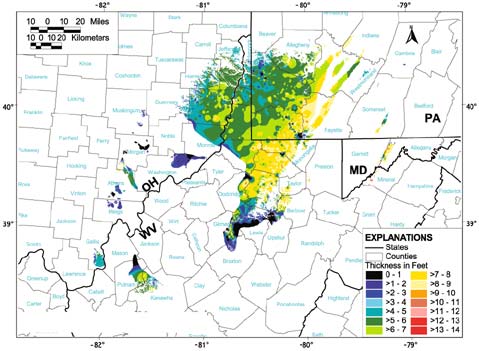
Contour maps come in all shapes, sizes, and types. The isopach map is one of those types. The isopach map uses isopach lines to show either rock or sediment thickness. These maps are beneficial when in search of an aquifer or gem mine. The map shown above captures the thickness of the Pittsburgh Coal bed in 1997. Judging from the graph, which uses isopach lines by thickness of feet, the thickest area of the Pittsburgh Coal bed looks to be about 9 or 10 feet and crosses over multiple counties.


Sunday, April 6, 2014

Isotach

http://www.hpc.ncep.noaa.gov/research/mcs_web_test_test_files/Page1947.htm

An Isotach map is a type of contour map that uses lines to illustrate wind speed in a given area. The Isotach map above from October 2006 shows strong winds heading east across Texas and into Arkansas and Louisiana. The Isotach lines are bending with wind speed and direction.

Topographic Map

http://www.americansouthwest.net/utah/grand_staircase_escalante/escalante-river-map.html

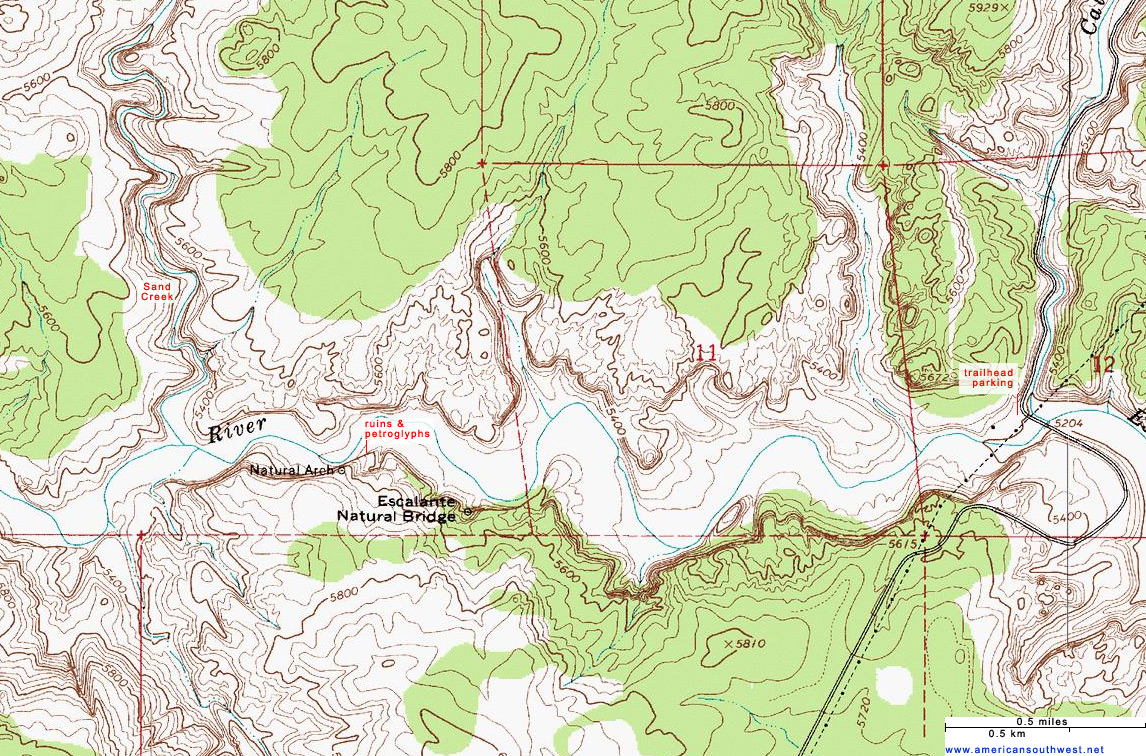
Topographic maps help cartographers reveal areas of elevation and the terrain of the land on a two-dimensional surface. This process is done through the use of contour lines that connect points that are equal in elevation. The topographic map shown above illustrates the elevation and terrain of the Escalante River trail, Grand Staircase at the Escalante National Monument in Utah. As you can see from the map the trail is along the Escalante River and there is only a slight 100 ft change in elevation along the trail. This type of map can serve a great purpose for hikers, engineers, and others who rely on the knowledge of elevation levels to complete tasks.  


Planimetric Map

http://sydney.edu.au/medicine/nepean/about/maps.php

A Planimetric map can be simply put as a surface map with no added relief features. This type of map conveys two dimensional information and is the type of map you would see on a GPS system. The planimetric map shown above is a street map focused on the location of the Sydney Medical School at the Nepean Hospital. As you can see this is a two dimensional portrayal of the area with no relief shown, it is simply streets. The planimetric is the most helpful when someone is  in need of directions and nothing else.


Wind Rose

http://snr.unl.edu/data/climate/wind.asp

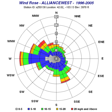
A Wind Rose is a type of circular plot that exhibits the prevalence of wind directions at a given location. The Wind Rose displayed above was generated from data collected at a station in Alliance, Nebraska from 1996-2005. The wind speed ranges from 0 mph to above 20 mph from 0% - 15% of the time. In this example the strongest winds occurred in the west blowing at a rate of 20 plus mph  for about 13% of the time. This type of graph can be very useful in determining typical wind speed and direction for a location.