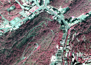
Infrared Aerial photographs are a type of remotely-sensed maps that are especially sensitive to the infrared spectrum. These photographs are taken in the air by either airplane or satellite. When using infrared aerial photography objects will become easier to detect and identify, in comparison with seeing the view through the human eye which is not sensitive to the infrared spectrum. This process is advantageous when trying to distinguish between multiple vegetation types as well as land and water. The infrared aerial photograph above is a photo of the Canyon Trail in Hot Springs National Park in Arkansas. You can clearly distinguish where the trail is from the rest of the photograph as well as the vegetation using infrared technology.
.
No comments:
Post a Comment